Flash Weather: April 25, 2015 Stormchase Recap
Chase #: 1
Date: Saturday, April 25
Locations: West Point, Leitchfield & Brownsville, Kentucky
Setup:An area of low pressure approached the Ohio Valley from the northwest on April 25th. Ahead of it, a strong warm front sharpened across southern Indiana and central Kentucky. South of the front, sunshine broke out and helped temperatures surge into the 80s, while north of the front temperatures were only in the 50s. At one point, there was a 40 degree temperature difference across the state of Kentucky from north to south! This strong front helped to focus severe thunderstorm development in the late afternoon and evening hours. Many of the storms that formed were rotating single storms, known as supercells, which dropped VERY large hail in some locations.
 Story: To start our chase, Lyssah & I targeted Elizabethtown, Kentucky, smack-dab in the middle of the greatest tornado threat zone.
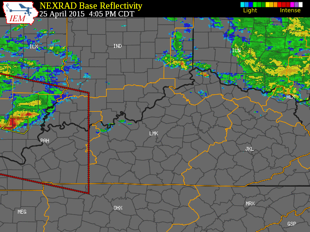
Riding along a northbound warm front, we noted dewpoints increasing with temps holding steady around 80° as we crossed the stateline. With winds howling out of the south/southwest and adequate shear aloft, no doubt, conditions were ripe for explosive development; however, as we entered Elizabethtown at 3:45 PM
CDT, the radar was still painfully quiet, thanks in part to a stubborn capping inversion. Despite the cap, we knew once it eroded, severe supercells would flair up all around us. Thus, we decided to chillax' at Elizabethtown until further notice.
 After a brief breather at Elizabethtown, Lyssah & I noted some action developing to our northwest. In response, we headed up 31W to intercept. Minutes later, as if on cue, a Severe Thunderstorm Warning went up for Hardin County.
 As the cell builded, I noticed high DBZ's forming at the cell's core, suggesting decent hail potential. In response, we positioned ourselves 5 miles north of the 60 turnoff near West Point.
The storm would eventually lay down some quarter-sized hail, granted many of them (like the ones in the picture) partially melted by time of picture's take.
 As we carried on, we decided to head west on 60 towards an organized QLCS rather than chase individual cells increasing to our east. Now, I'll admit...in hindsight, I probably would have chosen an eastbound track if given a second chance, as this would have positioned us towards the greatest hail growth zone; however, at the time, I felt a westward chase would ensure we'd have a higher probability of encountering some type of severe weather.
Photo by Cameron Fry (taken 7 miles north of McDaniels)

So we pressed west on 60, made a left onto 259 near Breckinridge, and turned our attention to an approaching squall line with potential embedded rotation; however, with the open road taking us into very rural territory, we decided to take shelter at one of the few non-residential establishments with covering...a small Baptist church between McDaniels and Leitchfield.
 Interestingly, this would turn out to be a blessing in disguise (or bummer...depending on your perspective), as our fifteen minute reprieve would ultimately delay us from experiencing the worst of the storm (granted at the time, we weren't aware of this). For as the QLCS matured into the next stage of its life cycle, an impressive hooking signal began to show on radar. Yet, with the most intense action shifting to our south, we decided to relocate.
After passing through the cities of Leitchfield on route to Brownsville, it wasn't long before the National Weather Service in Louisville issued a Tornado Warning for Edmonson County. Unfortunately, the lack of a quality signal following the warning issuance delayed my radar app from loading between 7:27-7:32 PM. Ironically, my LTE would kick in as we exited Leitchfield, with a new radar update revealing a classic comma-shaped bowing echo (i.e. a derecho with a possible spin-up tornado along its northern flank).
 At this point, I quickly realized we had stumbled into a near-jackpot situation (at least...by storm chasing standards)...as we were right back in the thick of it!
However, as we continued our southward track, I realized the odds of catching a potential tornado were growing less and less, as intense rains and the dark of night slowed our speed...not to mention, if we hadn't stopped at the church, we would have likely been ahead of the bow echo by a couple minutes as opposed to behind it.
By the time we entered into the Tornado Warning
polygon, the storm had started to weaken...and as we passed the northern townships of Brownsville, we noted moderate wind damage to trees and street/business signs, most likely due to strong straight-line/downdraft winds trigged by the collapse of a tornado. (Note: After reviewing the NWS damage report issued on April 26, we realized how the damage region we saw on 259 lined up well with an appropriated tornado track, had the twister stayed on the ground longer).
With the bow-echo continuing its deterioration into 8:00 PM, Lyssah & I decided to head towards Bowling Green on route to Nashville, as stunning lightning displays flashed overhead...


Sources

This work is licensed under a Creative Commons Attribution-NonCommercial-NoDerivs 3.0 United States License.
Date: Saturday, April 25
Locations: West Point, Leitchfield & Brownsville, Kentucky
Setup:
Riding along a northbound warm front, we noted dewpoints increasing with temps holding steady around 80° as we crossed the stateline. With winds howling out of the south/southwest and adequate shear aloft, no doubt, conditions were ripe for explosive development; however, as we entered Elizabethtown at 3:45 PM
CDT, the radar was still painfully quiet, thanks in part to a stubborn capping inversion. Despite the cap, we knew once it eroded, severe supercells would flair up all around us. Thus, we decided to chillax' at Elizabethtown until further notice.
After a brief breather at Elizabethtown, Lyssah & I noted some action developing to our northwest. In response, we headed up 31W to intercept. Minutes later, as if on cue, a Severe Thunderstorm Warning went up for Hardin County.As the cell builded, I noticed high DBZ's forming at the cell's core, suggesting decent hail potential. In response, we positioned ourselves 5 miles north of the 60 turnoff near West Point.The storm would eventually lay down some quarter-sized hail, granted many of them (like the ones in the picture) partially melted by time of picture's take.
As we carried on, we decided to head west on 60 towards an organized QLCS rather than chase individual cells increasing to our east. Now, I'll admit...in hindsight, I probably would have chosen an eastbound track if given a second chance, as this would have positioned us towards the greatest hail growth zone; however, at the time, I felt a westward chase would ensure we'd have a higher probability of encountering some type of severe weather. Photo by Cameron Fry (taken 7 miles north of McDaniels)
So we pressed west on 60, made a left onto 259 near Breckinridge, and turned our attention to an approaching squall line with potential embedded rotation; however, with the open road taking us into very rural territory, we decided to take shelter at one of the few non-residential establishments with covering...a small Baptist church between McDaniels and Leitchfield.
Interestingly, this would turn out to be a blessing in disguise (or bummer...depending on your perspective), as our fifteen minute reprieve would ultimately delay us from experiencing the worst of the storm (granted at the time, we weren't aware of this). For as the QLCS matured into the next stage of its life cycle, an impressive hooking signal began to show on radar. Yet, with the most intense action shifting to our south, we decided to relocate.After passing through the cities of Leitchfield on route to Brownsville, it wasn't long before the National Weather Service in Louisville issued a Tornado Warning for Edmonson County. Unfortunately, the lack of a quality signal following the warning issuance delayed my radar app from loading between 7:27-7:32 PM. Ironically, my LTE would kick in as we exited Leitchfield, with a new radar update revealing a classic comma-shaped bowing echo (i.e. a derecho with a possible spin-up tornado along its northern flank).
At this point, I quickly realized we had stumbled into a near-jackpot situation (at least...by storm chasing standards)...as we were right back in the thick of it!However, as we continued our southward track, I realized the odds of catching a potential tornado were growing less and less, as intense rains and the dark of night slowed our speed...not to mention, if we hadn't stopped at the church, we would have likely been ahead of the bow echo by a couple minutes as opposed to behind it.
By the time we entered into the Tornado Warning
polygon, the storm had started to weaken...and as we passed the northern townships of Brownsville, we noted moderate wind damage to trees and street/business signs, most likely due to strong straight-line/downdraft winds trigged by the collapse of a tornado. (Note: After reviewing the NWS damage report issued on April 26, we realized how the damage region we saw on 259 lined up well with an appropriated tornado track, had the twister stayed on the ground longer).
With the bow-echo continuing its deterioration into 8:00 PM, Lyssah & I decided to head towards Bowling Green on route to Nashville, as stunning lightning displays flashed overhead...
...no doubt, a fitting end to a memorable day of stormchasing.
Photo by Landon Hampton
Sources
- http://www.weather.gov/lmk/
- http://www.weather.gov/lmk/TornadoesfromApril25th2015
This work is licensed under a Creative Commons Attribution-NonCommercial-NoDerivs 3.0 United States License.


Comments